Covachón Fm
Type Locality and Naming
The formation is exposed mostly in the southwest corner of the Azuero Peninsula but may also occur as deformed slices in contact with the Azuero Mélange in the northwest edge of the Azuero Accretionary Complex (Buchs et al. (2011)). Facies 1, Covachón (539765/799275, UTM WGS84); Facies 2, Covachón (540545/799335, UTMWGS84); and Facies 3, close to the mouth of the Río Lajas (531490/796780, UTM WGS84). Covachón is accessible by an unpaved road from Cambutal. The mouth of the Río Lajas is accessible by boat from Cambutal or Búcaro. Exposures are accessible at low tide exclusively.
[Figure 1. A zoom-in of the Azuero Accretionary Complex which forms the SW edge of the Azuero Peninsula. It represents an accretionary complex composed of Cretaceous to Eocene accreted seamounts and oceanic islands. Modified from Buchs et al. (2008, 2011). Also in Barat (2013). The Covachón Fm is near the south.]
Synonym: Covachon Fm; wrongly spelled “Cobachon Fm” in post-2011 literature
Lithology and Thickness
Thickness: >300 m
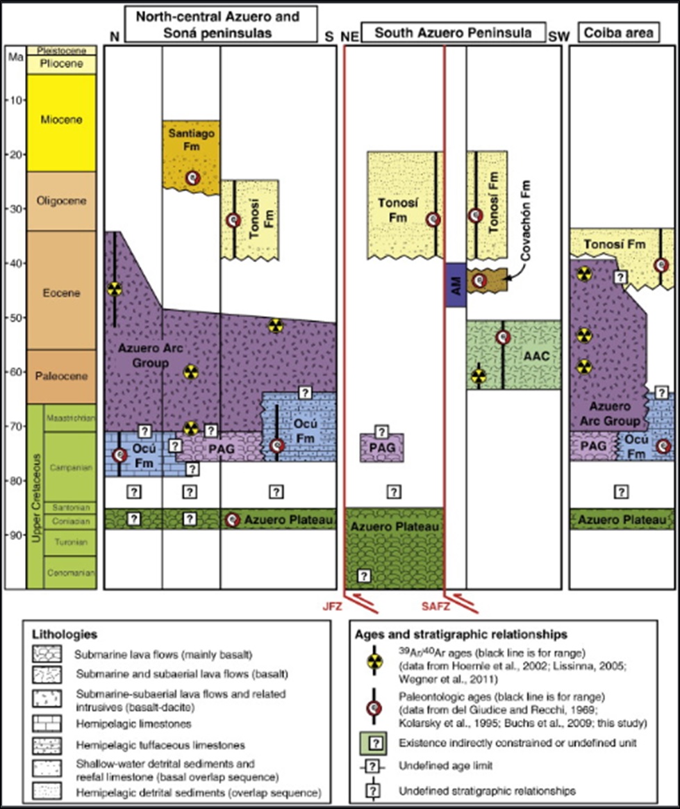
[Figre 2 Tectonostratigraphic chart showing the igneous complexes exposed on the Azuero Peninsula and surrounding areas as well as the sedimentary formations overlapping them. The ages of all formations/complexes were measured either by 40 Ar/39 Ar or Paleontologic methods (Barat (2013) and Modified from Buchs et al. (2008)). Note that Buchs et al. (2011) and Barat (2013) now includes the Pesé Fm as part of the Tonosí Fm, and the Macaracas Fm as the equivalent of the Santiago Fm.]
[Figure 3 (top). Lithic sandstones and siltstones from Facies 1 of the Covachón Fm at the mouth of the Lajas River on West Azuero Peninsula at 7°12'49.57"N 80°42'0.86"W. Ramirez (2013); (center). Mass-flow deposit (facies 2) from the Covachón Fm (Covachón, south Azuero Peninsula). Buchs (2008) and Buchs et al. (2011); (bottom). Pebbly sediments (facies 3) of the Covachón Fm (coastal exposure west of Río Lajas, south Azuero Peninsula) (Buchs (2008) and Buchs et al. (2011)). The conglomeratic sandstone of facies 3 can be observed at the mouth of the Lajas River at 7°12'45.07"N 80°42'5.47"W. Ramirez (2013)]
Relationships and Distribution
Lower contact
Upper contact
Regional extent
GeoJSON
Fossils
Age
Depositional setting
Additional Information
References: Buchs et al.; (2011) Ramirez (2013); Ramirez et al. (2016)


